Rutsiro is among seven districts making up Western Province, located 150km from Kigali. The district shares borders with Nyabihu and Rubavu districts in the North, Karongi district in the south, Ngororero in East and Lake Kivu that separates Rwanda with the Democratic Republic of Congo (DRC)in west.


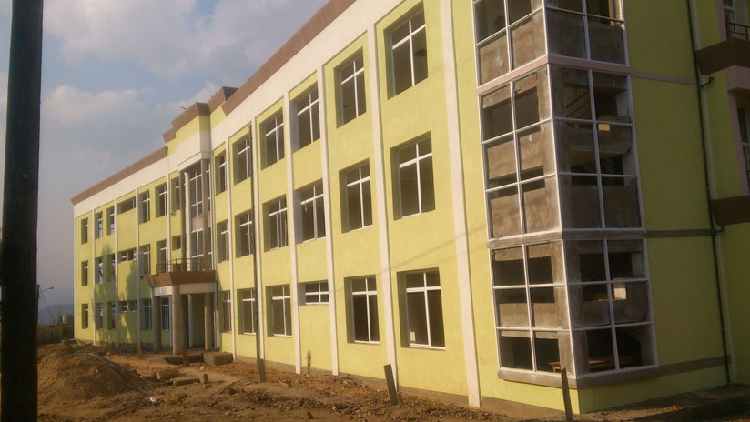
PHOTO: Rutsiro District office that is under construction.
Rutsiro is among seven districts making up Western Province, located 150km from Kigali. The district shares borders with Nyabihu and Rubavu districts in the North, Karongi district in the south, Ngororero in East and Lake Kivu that separates Rwanda with the Democratic Republic of Congo (DRC)in west.
The surface area of the district is 1,157.3km2, with altitude trict varying between 1,400 meters at the edge of Lake Kivu and 2,600 meters beyond the top of Mount Crete Congo-Nile.
The 4th Population and Housing Census of 2012 shows that Rutsiro district is home to more than 300,000 people, 47.4% of them are male and 52.6% are female with 57.2% of whole population under 19 years, whereas 34.2 are between 20-49; and from 50 and above 85 constitute 8.7%.
Rutsiro district has a tropical climate with an average temperature of between 20 ° and 24 ° C. Rainfall increases gradually as the district approaches the mountain range of Congo-Nile covered by Gishwati forest.
The district experiences passes through four seasons of the year; namely small rainy season that runs from September to December, the short dry season that runs from December to March, the long rain season that runs from the end of March to the end of June, and the long dry season that runs from the end of June to September.
However, on the other side the district experiences some irregularities like excess rainfall that sometimes causes homes and environmental destruction.
Rutsiro district is divided into thirteen sectors namely: Boneza, Gihango, Kigeyo, Kivumu, Manihira, Mukura, Murunda, Musasa, Mashonyi, Mushubati, Nyabirasi, Ruhango and Rusebeya. It is also divided into sixty two cells, and four hundred and eighty three villages.
Agriculture
As agriculture is the main economic activity in Rutsiro, the district targeted to improve post-harvest handling and increase add value addition for export crops.
The district constructed a greenhouse for Irish potatoes seedling multiplication in Nyabirasi sector.
They targeted to increase production of green and parchment coffee by facilitating farmers to access pesticides and fertilizers. The district also enhanced follow ups for good maintenance of coffee plantation and set strategies for production measurement.
The district targeted to produce 450tonnes of dry tea by facilitating farmers to access pesticides, fertilisers and application, follow up on good maintenance of tea plantation and setting strategies for production measurement; these measures resulted in increased production of 413.955 tonnes of dry tea.
Below is a table that shows agriculture development and land consolidation in year 2015-2016
Crops | Baseline | Target | Achievement | Percentage |


